


Bicycle Boulevard
A bicycle boulevard is a low-stress shared roadway bicycle facility, designed to offer priority for bicyclists operating within a roadway shared with motor vehicle traffic.
Case
Study
Application
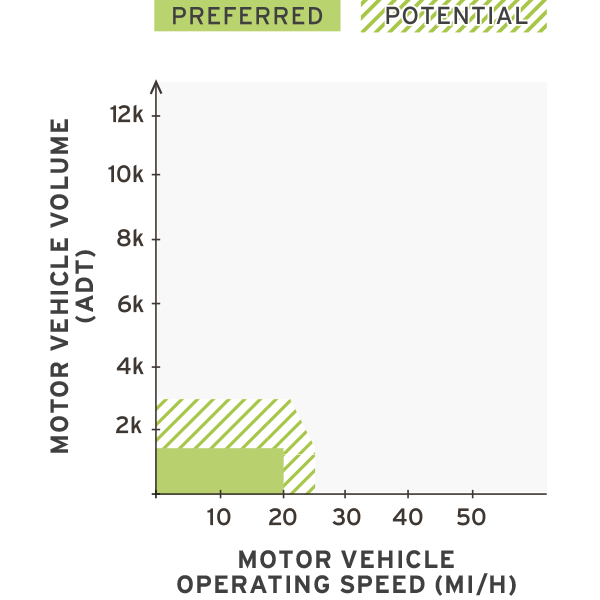

Photo Gallery
Benefits
-
Increases comfort for people bicycling by reducing motor vehicle operating speeds and volumes, if diversion is included.
-
Improves conditions for pedestrians when implemented with sidewalks and enhanced pedestrian crossings.
-
Improves the quality of life for residents through calmer traffic and safer crossings.
-
Connects local residential roads to commercial corridors and community services such as schools.
-
May reduce the incidence of serious injuries through reduced travel speeds.
-
Less visually impactful than separated facilities.
Considerations
-
May require additional paved surface to provide sidewalk space for pedestrians.
Introduction
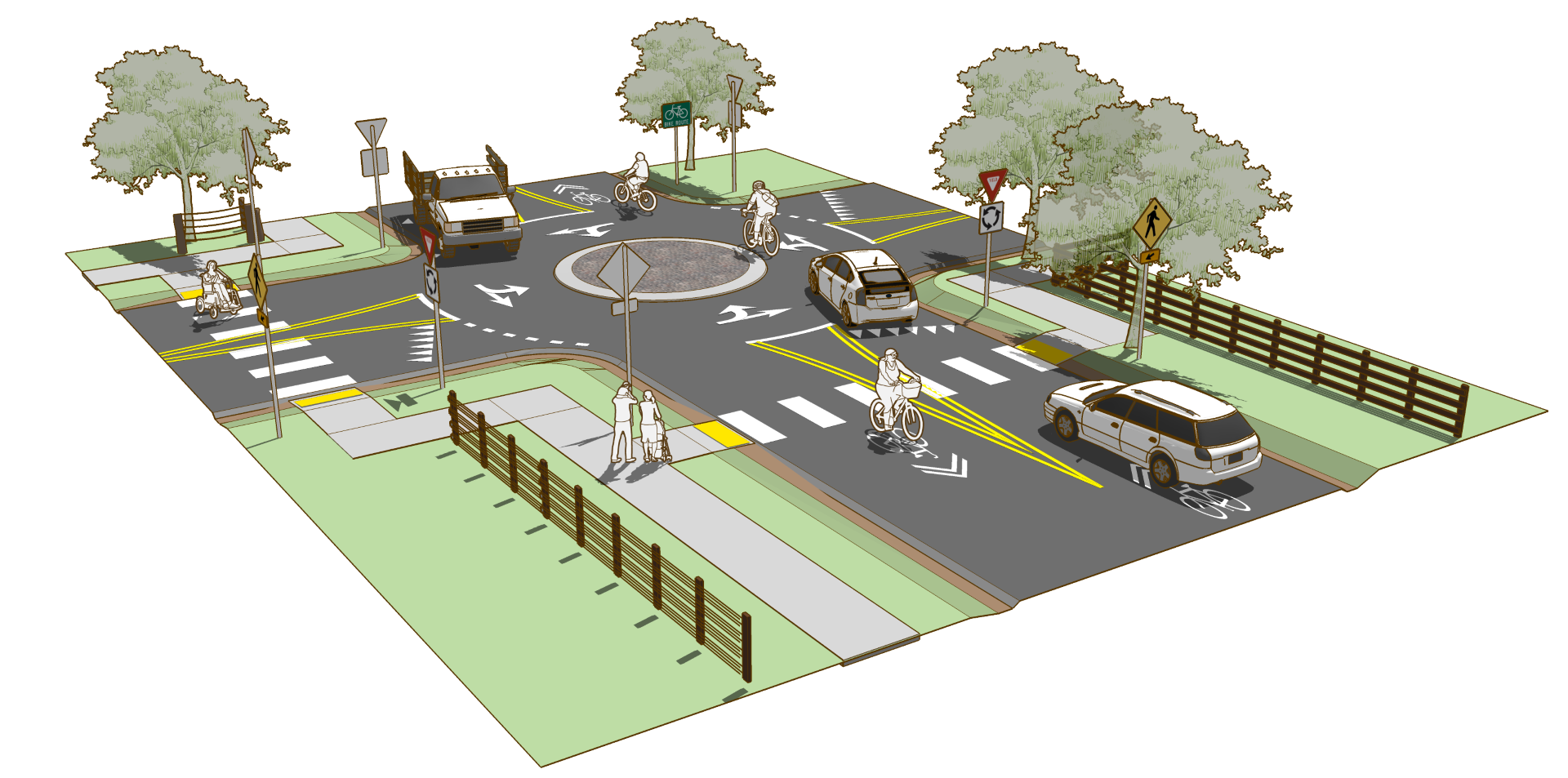
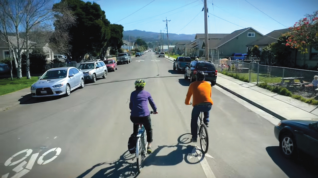
Bicycle boulevards provide a bicycle-priority route designed to offer convenient, low-stress access to local destinations and through neighborhoods. Combinations of access management, traffic calming, and crossing treatments work in concert to enhance the bicycling experience.
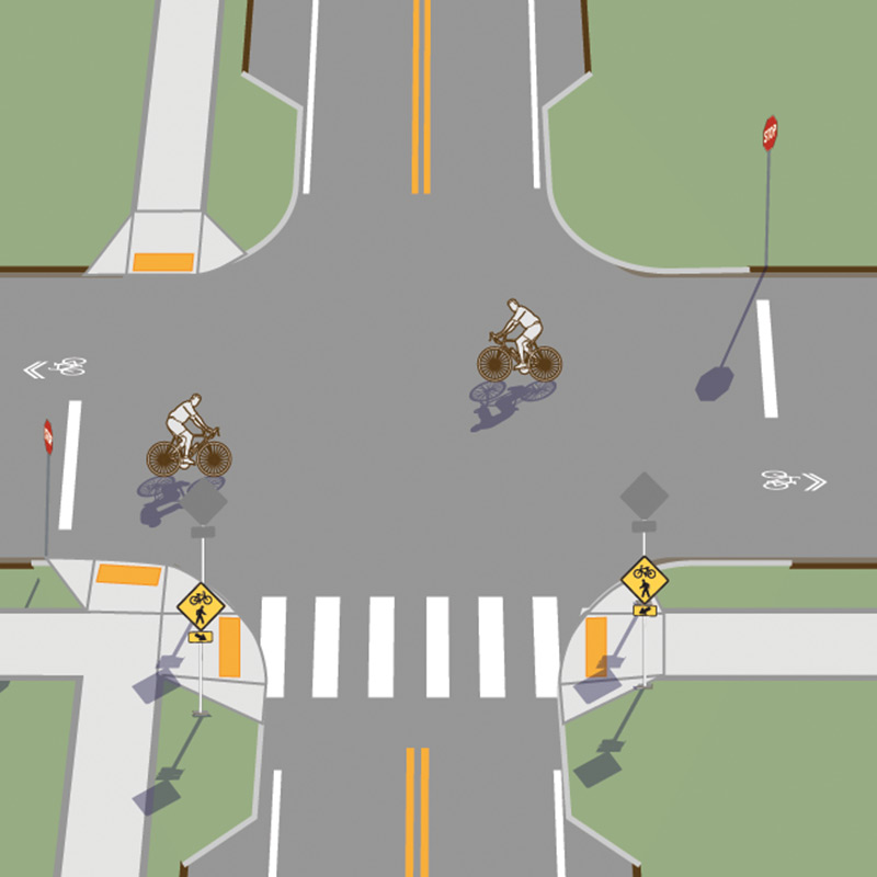
Figure 2-4. Common elements of a bicycle boulevard
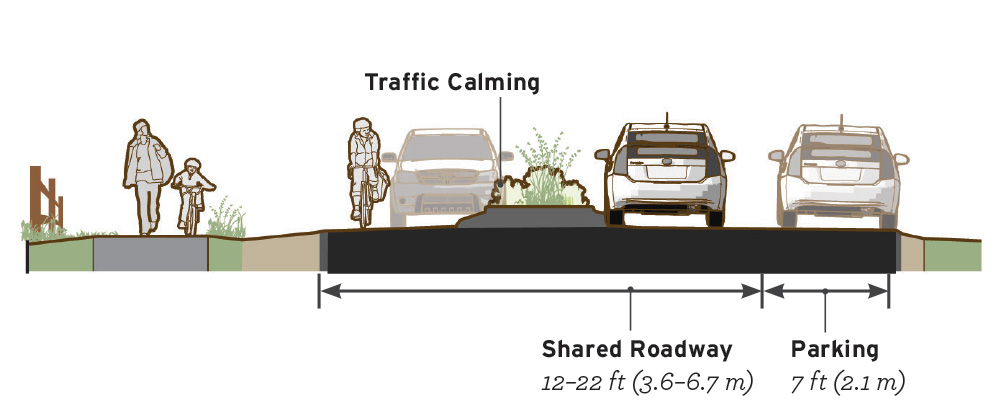
Geometric Design
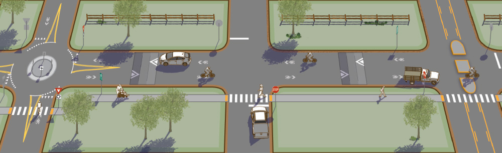
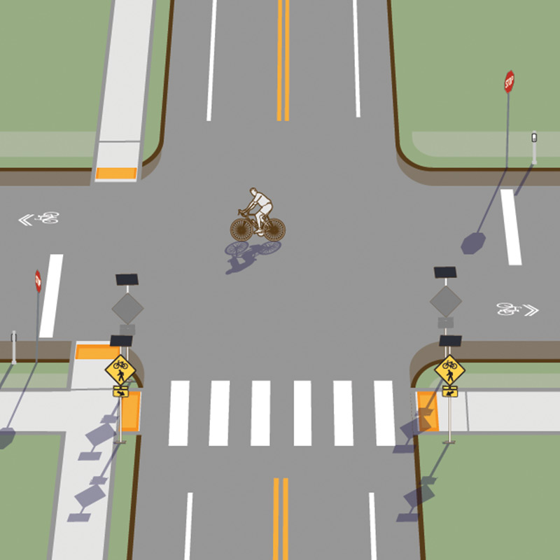
Figure 2-5. Bicycle boulevards combine road markings, traffic-calming measures, and crossing improvements designed to enhance the comfort and priority of bicyclists traveling along the route.
The AASHTO Bike Guide describes bicycle boulevards as streets “that have been modified to accommodate through bicycle traffic and minimize motor traffic” (2012, p. 1-2).
Many small town or rural local streets may have existing low-speed and low-volume traffic conditions that are ideal for bicycle boulevard implementation. In cases where speeds and volumes do not meet preferred values, traffic-calming techniques may be used to improve conditions. Even in curvilinear local street networks without cut-through traffic, speeding can be a problem on long, wide streets.
Speed reduction measures can help maintain vehicle speeds below 25 mi/h (40 km/h) and greatly improve bicyclists’ comfort on a roadway by reducing the overtaking speed differential between motor vehicles and bicyclists.
Markings
Use markings to encourage motorists to pass bicyclists at a safe distance.
- Do not mark a center line on bicycle boulevard facilities unless it serves as a short channelization device.
Clear identification of the bicycle boulevard is important for road user awareness of the facility.
- Shared lane markings (SLMs) are the standard marking for indicating shared roadway bicycle operations
- Place SLMs in the center of the travel lane to minimize wear and encourage riding a safe distance from parked cars.
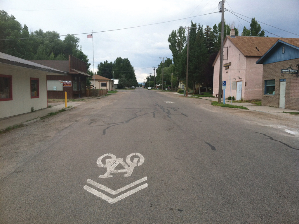
Ennis, MT – Population 850
Alta Planning + Design
![]()
San Luis Obispo, CA – Population 45,911
Adam Fukushima, City of San Luis Obispo
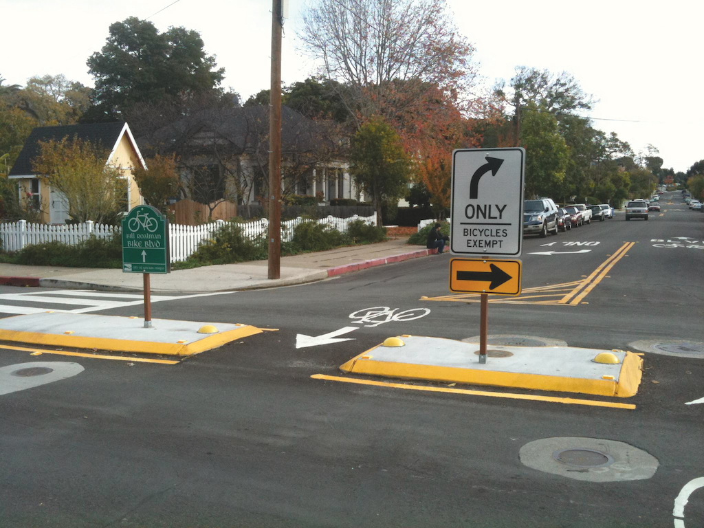
Signs
Route wayfinding is critical on bicycle boulevards when located along local routes with circuitous network connections. There are three functional types of wayfinding signs, illustrated in Figure 2-6:
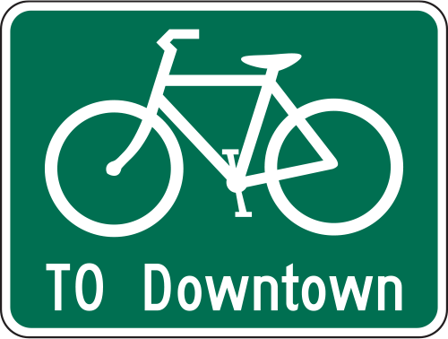
Confirmation Signs. Bike Route Guide (D11-1c) signs indicate to bicyclists that they are on a designated bikeway and make motorists aware of the bicycle route.
Turn Signs. A Bicycle Destination Sign (D1-1) with one or more destinations in a single direction indicates where a bike route turns from one street onto another street.
Decision Signs. Decision sign assemblies are a combination of D11-1c and D1-3a signs used to mark the junction of two or more bikeways and inform bicyclists of the designated bike route to access key destinations.
D11-1c

D1-1
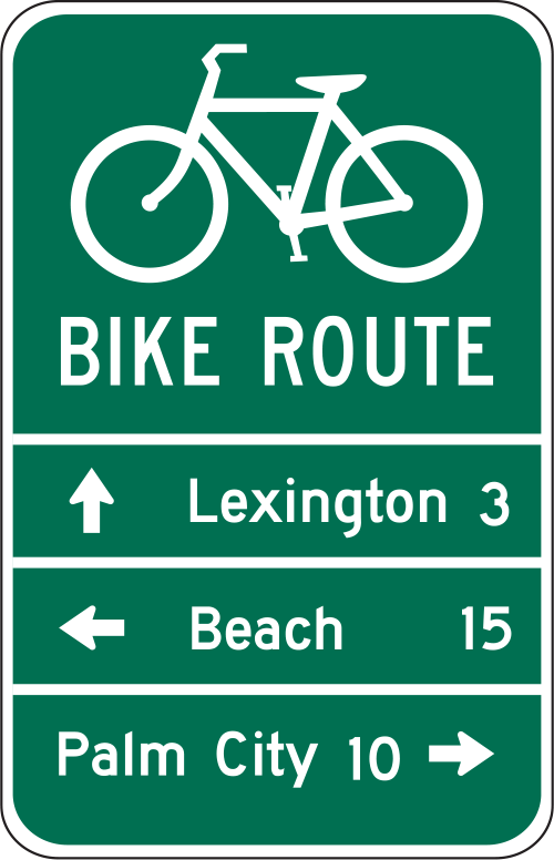
D11-1c; D1-3a
Figure 2-6. MUTCD guide signs for bicycle route navigation. The use of the D11-1c sign is preferred over D11-1 whenever practical, as it provides the reader with more useful information regarding the destination or route.
Intersections
Comfortable and intuitive intersection accommodations on bicycle boulevards are required to make the route attractive and functional for bicyclists of all ages and abilities. While crossings of local and minor collector streets may be comfortable with minimal modification, most local streets lack appropriate traffic control to safely and comfortably cross large streets. Crossing improvements should safely and comfortably accommodate pedestrians as well as bicyclists.
Minor Intersection CrossingsDesign treatments at minor roadway intersections to offer priority for bicyclists over cross-street traffic.
- Stops or yield signs should be oriented to favor the bicycle boulevard.
The quality of treatments at major street crossings significantly affect the utility of a bicycle boulevard route. Design crossing treatments to enhance safety and comfort for crossing users.
Refer to the National Cooperative Highway Research Program’s NCHRP 562 Improving Pedestrian Safety at Unsignalized Crossings Appendix A for a method to analyze an appropriate crossing treatments for a given roadway context. Evaluate the calculation assuming moderate bicycle and pedestrian activity to reflect the anticipated activity-level at the future enhanced crossing.
Figure 2-7 provides an example graph of crossing guidelines following NCHRP 562 methodology. This should only be used when the major-road speed, the pedestrian walking speed, and the crossing distance are matched to the value presented at the top of the graph. For other situations, the reader should use the equations listed in the Appendix A worksheets.
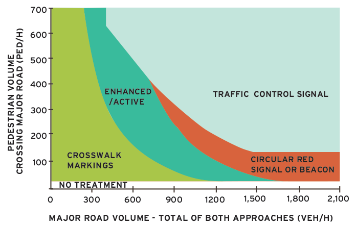
Figure 2-7. Example Guidelines for Pedestrian Crossing Treatments adapted from NCHRP 562 (Fig. A-5). Calculations assume 34 ft (10.4 m) Pavement, 35 mi/h (55 km/h), 3.5 ft/s (1.1 m/s) Walking Speed.
Implementation
Development of bicycle boulevards in rural settings can often be challenging due to a lack of alternate through roadways and the concentration of motor vehicle traffic on arterials. Disconnected road networks may maintain low traffic speeds and discourage through traffic on local roads, but these benefits often sacrifice connectivity.
Accessibility
Bicycle boulevards are designed to prioritize use by bicyclists and are not intended for use by pedestrians. On bicycle boulevards, the appropriate pedestrian facility is generally a sidewalk. If the bicycle boulevard is intended to facilitate pedestrian travel within the roadway it must be accessible.
Crossing enhancements can use a variety of engineering tools to address user comfort, provide additional gap acceptance opportunities, and increase yield to pedestrian rates.
For more information on crossing enhancements for bicycle boulevards, refer to BIKESAFE 2014.
Figure 2-8. The following images illustrate some potential crossing enhancements for increasing the safety and comfort of bicycle boulevard crossings of other roadways.
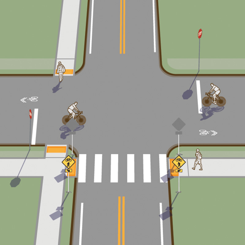
Crosswalk Markings and Crossing Warning Signs
Crosswalk markings and warning signage raise awareness of the crossing by motorists. Use a combined bicycle and pedestrian W11-15 sign to indicate the potential of bicyclists and pedestrians crossing at specific locations.
Curb Extensions
Curb extensions reduce traffic exposure and increase visibility of crossing users. Curb extensions should not be used within shoulders where they interfere with bicycle travel along the major roadway.
Active Warning Beacons
At locations with poor yield-to-pedestrian compliance, install active warning beacons such as rectangular rapid flashing beacons to supplement crossing warning signs and remind motorists of the obligation to yield. Refer to FHWA Interim Approval 11 for more information on the use and application of rectangular rapid flashing beacons.
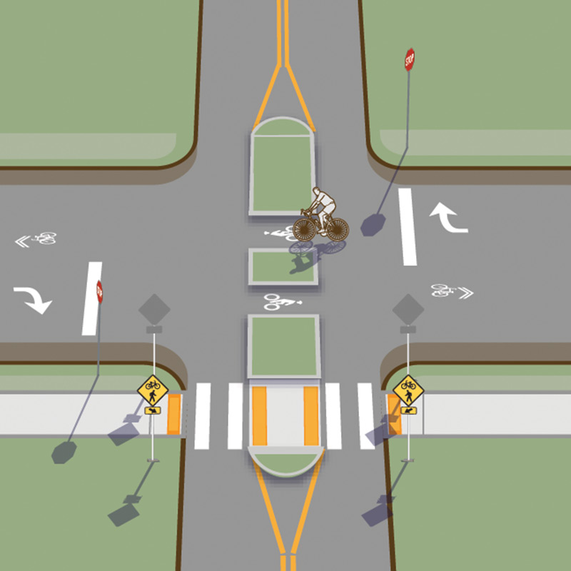
Median Islands
Divide crossings into multiple stages with a median safety island. This allows crossing bicyclists and/or pedestrians to accept gaps in traffic one direction at a time. Median safety island for bicycle boulevards should be at least 8 ft (2.4 m) deep to accommodate crossing bicyclists.
Median islands are an FHWA Proven Safety Countermeasure.
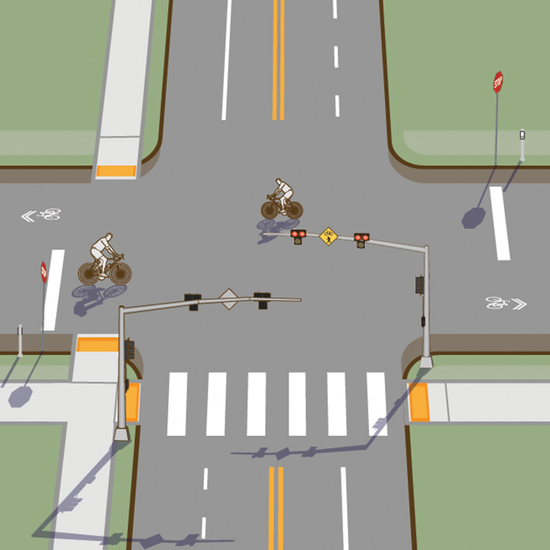
Pedestrian Hybrid Beacons
At locations with multiple lanes of traffic, high-speed traffic, and/or no opportunity for a median safety island, a full traffic signal or pedestrian hybrid beacon may be effective in creating safe crossing conditions. Pedestrian hybrid beacons are an FHWA Proven Safety Countermeasure. Refer to the FHWA Pedestrian Hybrid Beacon Guide 2014 and MUTCD Chapter 4F for more information.
Bicycle Boulevard Case Study
Arcata, California
The objective of the Arcata Bicycle Boulevard project was to create a more balanced and multimodal transportation system that provided facilities for walking and biking. Bicycle boulevards play an important role in a bicycle network, by providing a traffic calmed street for bicyclists of all ages and abilities.
The Arcata Bicycle Boulevards were implemented roadways with low traffic volumes (fewer than 2,000 cars per day), which run parallel to high-volume roadways (11th and H Streets). The boulevards connect critical destinations throughout the community, including connecting Aracta High School to downtown Arcata and the Arcata Marsh and Wildlife Sanctuary. The facilities also connect to public transportation at the Arcata Intermodal Transit Facility on 10th Street. The boulevard connects to Q and 11th Streets, where a future pedestrian and bicycle shared use trail is planned along south Q Street, leading toward the Arcata Marsh.
Special attention was given to bicyclists at intersections, where it is important to give bicyclists priority to maintain free-flow travel. Mini traffic circles slow motor vehicle traffic at minor intersections, while allowing bicyclists to continue through the intersection. Traffic calming at intersections also included public art to slow motor vehicle speeds, as seen at the intersection of 10th and I Streets.
Community Context
Arcata is a university town located along Arcata Bay in northern California. The 2010 population was 17,231, with many visitors in the summer.
Key Design Elements
Custom wayfinding signs, pavement markings, and landscaped curb extensions, which act as a traffic calming element, were used in this project. Traffic controls were put in place at intersections to help bicyclists cross major intersections at 10th and K Streets, 11th and I Streets, and 11th and Q Streets. Additional bike parking was also installed along the bike boulevard at popular destinations.
Role in the Network
Bicycle boulevards were identified as key projects in the Arcata Pedestrian and Bicycle Master Plan in 2005 and 2010. This project provides connections between important community destinations, as well as future or planned projects.
Funding
In December 2006, the Public Works Department received a Caltrans Bicycle Transportation Account (BTA) grant for $173,612. The grant funded the
bicycle boulevard improvements, as well as an intersection study, education and awareness programs, and bicycle parking in downtown Arcata.
For more information refer to the City's website.
Selected Examples
Works Cited
Ewing, R., Steven, J. U.S. Traffic Calming Manual. 2009.
Federal Highway Administration. Bicycle Safety Guide and Countermeasure Selection System. 2014.
Federal Highway Administration. Interim Approval for Optional Use of Rectangular Rapid Flashing Beacons (IA-11). 2008.
Federal Highway Administration. Manual on Uniform Traffic Control Devices. 2009.
Federal Highway Administration. Pedestrian Hybrid Beacon Guide. 2014.
Federal Highway Administration. Proven Safety Countermeasures. 2012.
NCHRP Report 562: Improving Pedestrian Safety at Unsignalized Crossings. 2007.