


Bike Lane
Bike lanes designate an exclusive space for bicyclists through the use of pavement markings and optional signs. A bike lane is located directly adjacent to motor vehicle travel lanes and follows the same direction as motor vehicle traffic.
Case
Study
Application
Photo Gallery
Benefits
-
Provides additional separation distance between the sidewalk and motor vehicle travel area, if a sidewalk is present.
-
Provides a designated space on the roadway suitable for many skilled bicyclists within built-up areas of small communities.
-
Provides additional visual cues to drivers that they should expect bicyclists on the roadway. This can be particularly useful when transitioning to a built-up area from a highway context.
-
Connects and completes bikeway networks through built-up areas.
-
Can support school access by bicycle when configured as a wide bike lane on lower-speed, lower-volume streets.
Considerations
-
Reflects a more urban visual atmosphere than an unmarked shoulder.
Introduction
Within built-up areas, increased pedestrian activity and curbside uses degrade the experience of nonexclusive bicycling accommodations such as shoulders. Providing a designated bike lane can provide a consistent area for bicyclists to travel outside the path of motor vehicles. When space is available, add a buffer area, distancing the bike lane from the adjacent motor vehicle travel lane.
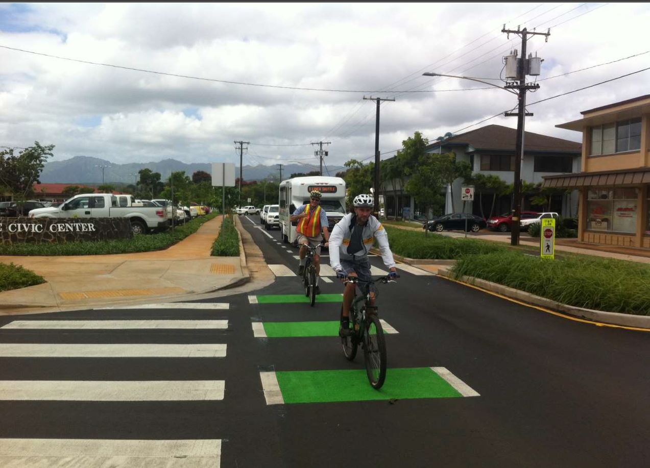
South Lake Tahoe, CA – Population 21,380
Tahoe Regional Planning Agency (TRPA)
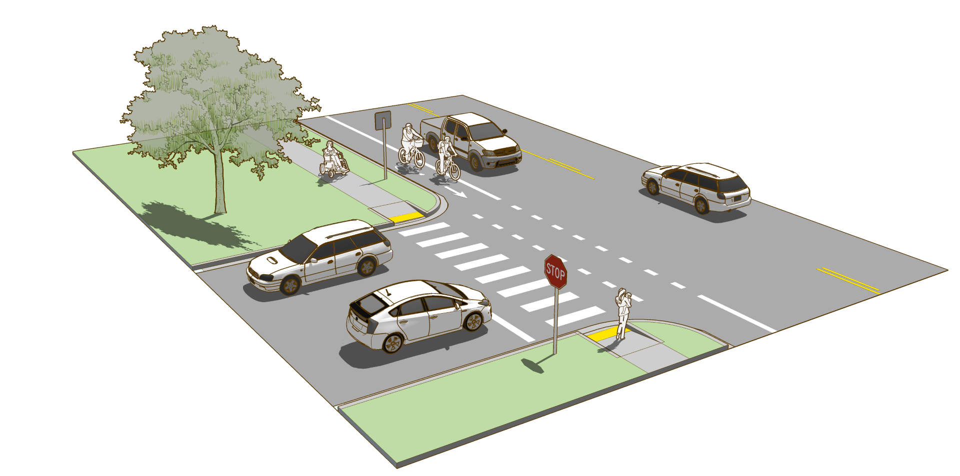
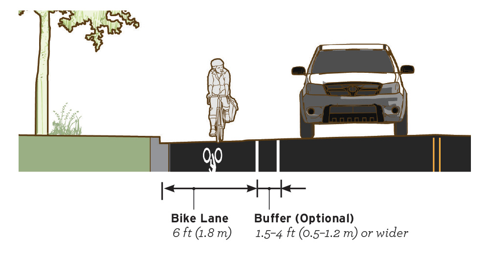
Figure 3-7. Bike lanes establish an area for exclusive bicycle use outside the path of motor vehicles.
Geometric Design
BIKE LANESDesign bike lanes to separate road users and reduce the stress of motor vehicle passing events.
- The preferred minimum width of a bike lane is 6.5 ft (2.0 m) to allow for bicyclists to ride side-by-side or pass each other without leaving the bike lane.
- Absolute minimum bike lane width is 4 ft (1.2 m) when no curb and gutter is present or 5 ft (1.5 m) when adjacent to a curbface, guardrail, other vertical surface or on-street parking stalls (AASHTO Bike Guide 2012).
- Widths 7 ft (2.1 m) or greater may encourage motor vehicle use of bike lane for parking or driving. If extra width is available or desired, configure with a buffer zone to delineate space.
Markings
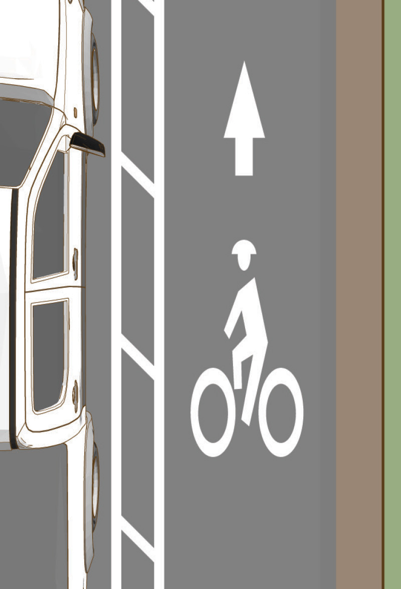
Mark a bike lane line with a normal solid white line and a standard bike lane symbol marking. Standards and guidance for applying these elements can be found in the MUTCD 2009.
Lane markings should remain solid and not dotted at driveway crossing. The MUTCD does not recognize a driveway as an intersection (MUTCD 2009, AASHTO Bike Guide 2012).
Buffer ZoneBike lanes may be enhanced with a longitudinal marked buffer area for more separation distance. This treatment is appropriate for bike lanes on roadways with high motor vehicle traffic volumes and speed, adjacent to parking lanes, or a high volume of truck or oversized vehicle traffic.
- A minimum width buffer of 1.5 ft (0.5 m) may be bound by two solid lines, without interior markings.
- If the buffer is 4 ft (1.2 m) or wider, mark with diagonal or chevron hatching.
For more information on buffer zone striping and application, refer to NCHRP 766–Recommended Bicycle Lane Widths for Various Roadway Characteristics 2014.
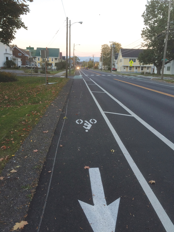
Figure 3-8. Helmeted bicyclist symbol inside a bike lane with a painted buffer area.
Signs
An optional bike lane sign may be used to supplement the bike lane pavement markings. Standards and guidance for applying these elements can be found in the FHWA MUTCD.
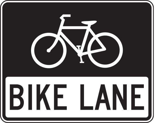
Figure 3-9. An optional R3-17 Bike Lane sign may be used to supplement bike lane markings. An R7-9 sign may be used if parked vehicles frequently bock the bike lane.
Intersections
Design strategies for bike lanes at intersections emphasize reducing speeds, minimizing exposure, raising awareness, and communicating right-of-way priority.
- Under most conditions, bicyclists have priority over turning traffic. Markings and signs should support this priority and remind motorists of the obligation to yield.
- Adjacent to a through-right lane, use a modified R10-15 Turning Vehicles Yield to Bikes sign to clarify user priority.
- Where a right-turn lane is established to the right of a bike lane, R4-4 Begin Right Turn Lane Yield to Bikes sign reminds motorists to yield to bicyclists before entering the lane.
- Where special emphasis is desired, green pavement color may be used within bike lanes and at merging or weaving areas where motor vehicles may cross bike lanes. For more information on the use of color, refer to FHWA Interim Approval 14 2011.
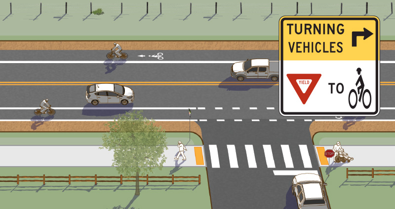
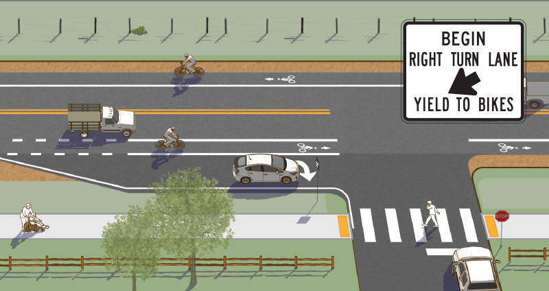
Figure 3-10. A variety of design treatments exist depending on the roadway configuration, available curb-to-curb width, traffic volumes and desire to provided a dedicated turn lane. All designs should strive to reduce speeds of turning vehicles, remind users of bicycle priority, and clarify user positioning approaching and through the intersection. Common signs at intersections include R4-4 Begin Right Turn Lane Yield to Bikes and a modified R10-15 Turning Vehicles Yield to Bikes sign.
Implementation
Include or upgrade shoulders during roadway resurfacing, rehabilitation, and reconstruction and in new construction projects. For more information on implementation strategies, refer to FHWA Resurfacing Guide 2016.
Bike Lane Case Study
Lyndonville, Vermont
The Lyndonville planner worked with the Vermont Agency of Transportation (VTrans) during the construction of a large repaving project through Lyndonville to incorporate bike lanes into the project. Bike lanes were incorporated on Main Street, Broad Street, and Center Street. Along Depot Street, shared lane markings are the preferred option given on-street parking. On the Main Street section of the project, the existing roadway had no parking and wide shoulders. This combination allowed VTrans to design painted buffered bike lanes.
The addition of buffered bike lanes to the already under construction paving project was possible through the use of painted buffers. In addition, green paint was added at the bike lane through the intersections to highlight the areas of potential conflict. Because of variable shoulder widths, the painted buffer has a constant width of 2 ft while the bike lane width varies between 5 and 8 ft.
Community Context
Lyndonville, population 1,207, is a village within the town of Lyndon, VT. Located in Vermont’s rural Northeast Kingdom, Lyndonville is home to Lyndon State College with approximately 1,400 students. Nearby Burke Mountain offers lift access downhill mountain biking, and Kingdom Trails anchors a growing network of mountain bike trails in the region.
Key Design Elements
Painted buffered bike lane with additional pavement markings.
Role in the Network
The buffered bike lanes on Main Street are part of the network of on-street bike lanes and shared streets that connect the downtown businesses with residential streets and Lyndon State College.
Funding
The bike lanes were included as part of the paving project which was funded with 81 percent Federal funds and 19 percent State funds. Being incorporated into a planned and funded paving project meant that the additional costs for the buffered bike lanes were minimal.
For more information, refer to the Vermont Agency of Transportation.
Selected Examples
Works Cited
American Association of State Highway and Transportation Officials. Guide for the Development of Bicycle Facilities. 2012.
Federal Highway Administration. Incorporating On-road Bicycle Networks into Resurfacing Projects. 2016.
Federal Highway Administration. Interim Approval for Optional Use of Green Colored Pavement for Bike Lanes (IA-14). 2011.
Federal Highway Administration. Manual on Uniform Traffic Control Devices (MUTCD). 2009.
Federal Highway Administration. Separated Bike Lane Planning and Design Guide. 2015.
NCHRP. Report 766 - Recommended Bicycle Lane Widths for Various Roadway Characteristics. 2014.