


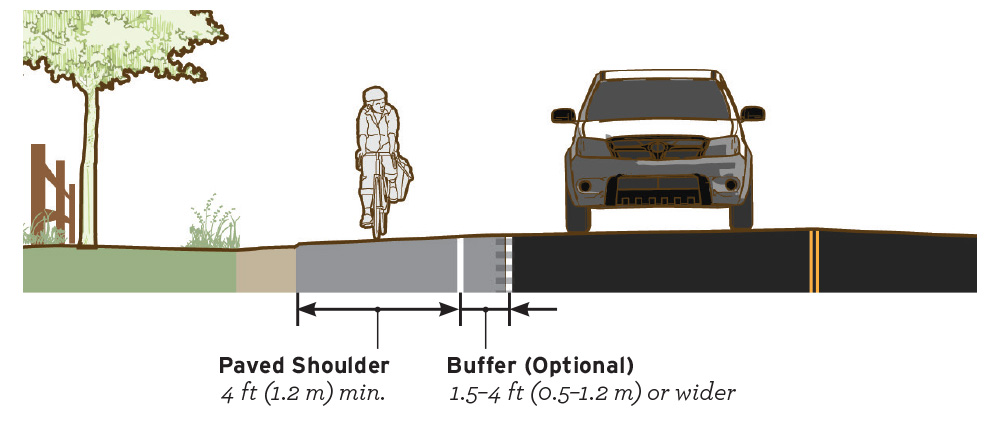
Paved Shoulder
Paved shoulders on the edge of roadways can be enhanced to serve as a functional space for bicyclists and pedestrians to travel in the absence of other facilities with more separation.
Case
Study
Application
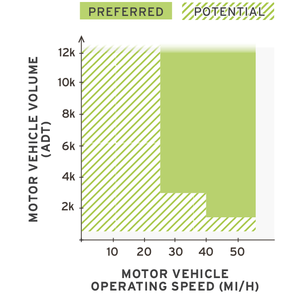

Photo Gallery
Benefits
-
Improves bicyclist experiences on roadways with higher speeds or traffic volumes.
-
Reduces pedestrian “walking along roadway” crashes.
-
Provides advantages for all roadway users, by providing space for bicyclists, pedestrians, and motor vehicles.
-
Provides a stable surface off the roadway for pedestrians and bicyclists to use when sidewalks are not provided.
-
Can reduce “bicyclist struck from behind” crashes, which represent a significant portion of rural road crashes.
Considerations
-
Enhancements with increased levels of striping and signs may interfere with the low-clutter character of a rural environment.
-
Requires a wider roadway to provide an accessible shoulder space.
Introduction
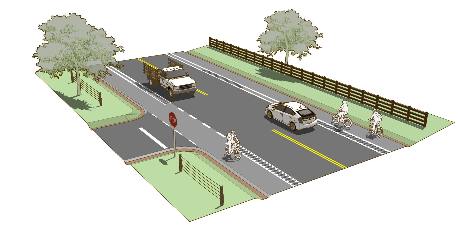
Shoulders can improve bicyclist comfort and safety when traveling in higher speed and/or volume situations but only when adequate width is provided. If used, locate rumble strips on the edge line or within a buffer area that will not reduce usable space for bicyclists.
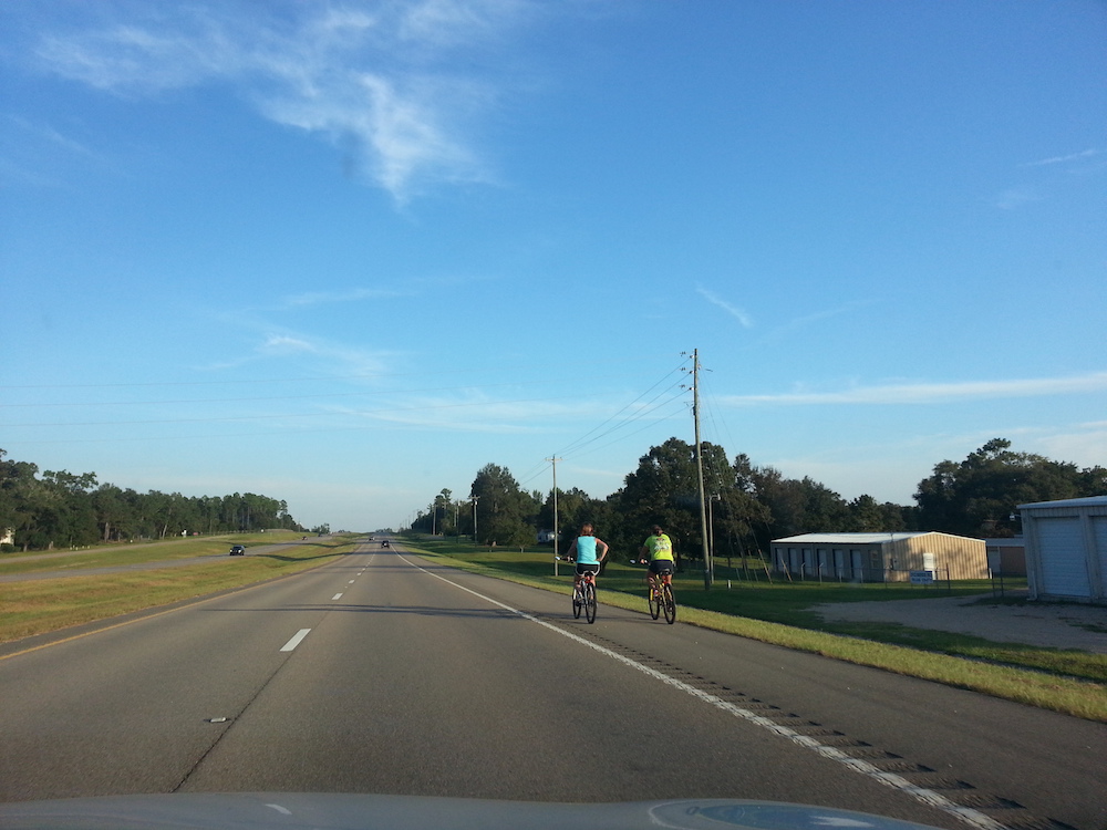
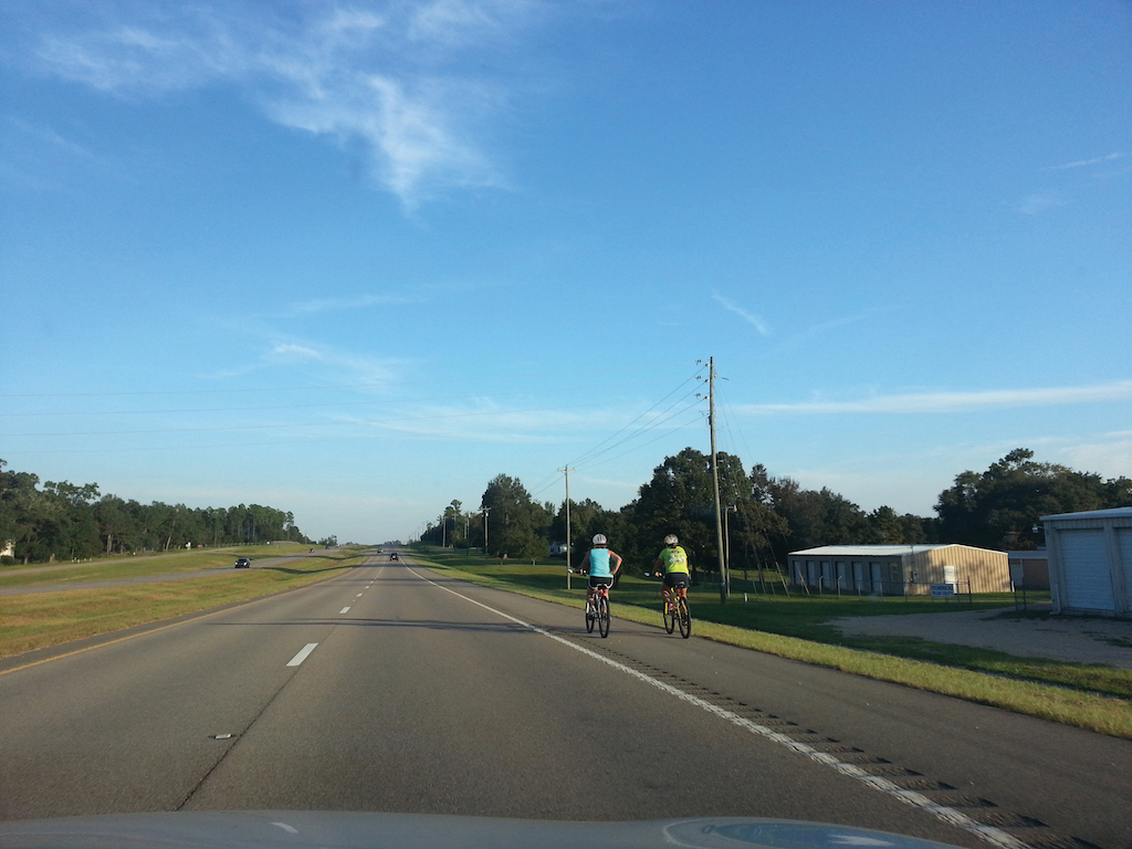
Figure 3-1. When adequate width is provided, shoulders can serve bicycle trips along roads too busy for comfortable shared roadway travel.
Geometric Design
Any amount of clear paved shoulder width can benefit pedestrians and bicyclists, however, to be fully functional for their use, the paved shoulder area should be wide enough to accommodate the horizontal operating envelope of these users.
- To accommodate bicyclists and pedestrian use of the shoulder, provide a minimum width of 4 ft (1.2 m) adjacent to a road edge or curb, exclusive of any buffer or rumble strip.
- Where possible, provide greater width for added comfort, user passing, and side-by-side riding.
Table 3-1. Recommended Minimum Paved Shoulder Widths by Roadway Conditions
D’Iberville, MS – Population 10,390
Alta Planning + Design
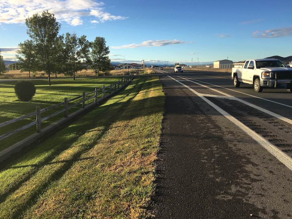
Highway 2, Nebraska
Bob Boyce via Ped Bike
Rumble strips are an FHWA Proven Safety Countermeasure for reducing roadway departure crashes. Research has shown that installing rumble strips can reduce severe crashes but may negatively impact bicycle travel if they are poorly constructed.
Additional information on rumble strip design can be found in FHWA Technical Advisory 5040.39 and on the FHWA Rumble Strips and Rumble Stripes Website.
- If rumble strips are desired on bicycle network routes the dimension, optimize the dimension, design and placement of rumble strips to be more tolerable to bicyclists.
- 12 inch spacing center-to-center
- 6–8 inches long, perpendicular to roadway
- 6 inch wide, measured parallel to roadway
- 3/8 inch deep
- Place rumble strips to overlap with the roadway edgeline, also known as edgeline rumble strips or rumble stripes.
- Provide a bicycle gap pattern to allow access into and out of the shoulder area by bicyclists. The gap pattern consists of a 12 ft (3.3 m) clear gap followed by rumbles, typical 40–60 ft (12.1–18.2 m) (NCHRP Synthesis 490, 2016).
Contrasting or colored pavement materials may be used to differentiate the shoulder from the adjacent travel lanes (AASHTO Green Book 2011, p. 4-13).
- Colored pavement in a paved shoulder is an aesthetic treatment to enhance awareness and is not intended to communicate a regulatory, warning, or guidance message to road users.
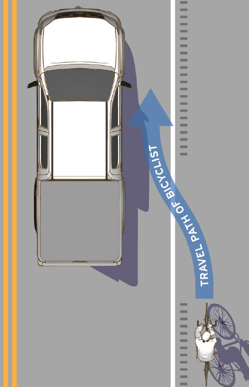
Figure 3-2. Preferred rumble strip dimensions and placement. Figure from FHWA Achieving Multimodal Networks 2016.
Markings
On shoulders designed for bicycle and pedestrian accessibility, the edge should be clearly delineated and defined to discourage unnecessary encroachment by motor vehicles. Options beyond a normal white line include:
Discontinue the edge line at intersections and major driveways. On a bicycle accessible shoulder, additional definition of the shoulder alignment may be desired. In these conditions, consider:
- A dotted white line to extend the edge line through intersections and major driveways.
- A second normal width dotted white line may be used to define the outside edge of the shoulder, defining both sides of the bicycle travel area.
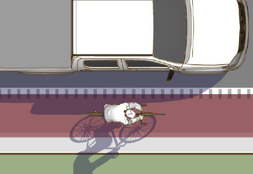
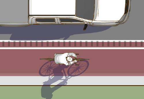
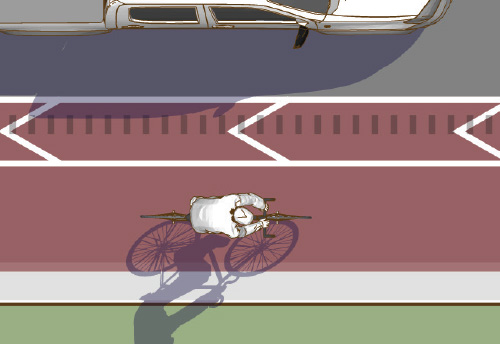
Figure 3-3. Longitudinal markings along shoulders should be selected in response to shoulder width, and the desire to discourage encroachment by motor vehicles.
Signs
No signs are required on paved shoulders, but signs may be used to identify a road as a bicycle route.
- Bike Route Guide (D11-1c) signs are used to indicate to bicyclists that they are on a designated bikeway and make motorists aware of the bicycle route.
Intersections
At intersections, the shoulder area is often narrowed to provide room for or completely replaced by turning, receiving or bypass lanes. It is important to minimize the impacts of these designs to bicyclists using the shoulder for bicycle travel.
At intersections with heavy left-turn volumes, an auxiliary bypass lane, or center turn lane may be provided for motor vehicles. While this lane may encroach into the shoulder space, 6 ft (1.8 m) of the shoulder should be preserved for bicyclist travel. Absolute minimum width of the shoulder is 4 ft (1.2 m) to maintain bicycle accessibility.
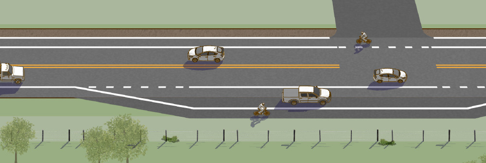
Figure 3-4. At bypass lanes, widen the roadway to provide a clear shoulder area outside of the travel area. (Based on Figure 4-7 in the AASHTO Bike Guide, 2012.)
Paved shoulders are typically located immediately to the right of right turn lanes. This may lead to right-hook conflicts between through bicyclists and turning vehicles. At intersections with right turn only lanes, bicycle accessible shoulders should be classified as bike lanes or separated bike lanes, and appropriate intersection designs should be used to encourage safe interactions.
A right turn lane should be added to the right of the bike lane. Dotted line extensions should be used to define the tapered entrance into the right-turn lane, and signs should direct motorists to yield to bicyclists. For more information, refer to the guidance on bike lanes and FHWA MUTCD Figure 9C-4.
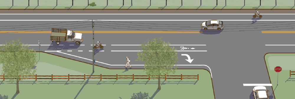
Figure 3-5. In this scenario, the shoulder is designated as a bike lane and a right turn lane is introduced to the right of the bike lane. Drivers must yield to through bicyclists before entering the turn lane.
Where a high degree of user comfort is desired, the shoulder may transition into a one-way separated bike lane or shared use path in advance of intersections. Once established, the separated facility may maintain separation up to the crossing. This increased separation provides an opportunity for motorists to slow in advance of the turn and yield to bicyclists. For more information, refer to the guidance on separated bike lanes.
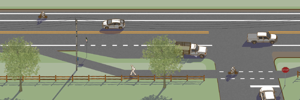
Figure 3-6. In this scenario, the shoulder is designated as a separated bike lane. Bicyclists are shifted laterally away from the roadway and separated from the travel or turn lanes by an unpaved buffer space.
Implementation
Include or upgrade shoulders during roadway resurfacing, rehabilitation, and reconstruction in new construction projects. For more information on implementation strategies, refer to the FHWA Resurfacing Guide 2016.
Accessibility
When shoulders are intended for use by pedestrians, they must meet accessibility guidelines.
Paved Shoulder Case Study
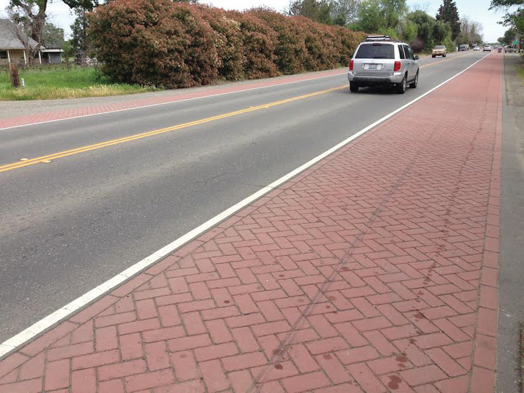
Capay, California
State Route (SR) 16 through the Capay Valley has a wide variety of users including commuters, recreational travelers, freight truck drivers, and farm equipment operators. Capay Valley contains farmland, several small communities, and the Cache Creek Casino Resort. This part of SR 16 is designated as a local Scenic Highway, and is also eligible to become a State Scenic Highway. As SR 16 approaches Interstate 505, the route goes through the unincorporated communities of Esparto and Madison, which are expected to grow in population over the next 20 years from planned development.
The California Department of Transportation (Caltrans) has identified SR 16 corridor safety needs through several studies including a 2012 Transportation Corridor Concept Report. The paved shoulders were installed as part of a Caltrans Traffic Calming project within the community of Capay which was completed in December 2011. The enhancements included pigmented and textured shoulders, restriping, improved signage, and architectural, landscaping, and lighting improvements. The improvements along SR 16 have been a partnership effort among Caltrans, Yolo County, the Sacramento Area Council of Governments, a Native American Tribal Government, and the community.
Community Context
Capay is a small, unincorporated community in northern California’s Yolo County, with an estimated population of 133. Yolo County’s 2010 population was 200,000, including Davis, with a population of 65,000. Yolo County is in the Sacramento Valley and remains largely a rural agricultural region.
Key Design Elements
The existing highway through Capay had wide shoulders that were used by people walking and on bikes to access the businesses along SR 16. The paved shoulders were created using pigmented, stamped asphalt which is a relatively inexpensive treatment with low maintenance costs.
Role in the Network
SR 16 connects the rural communities of Yolo County with Woodland and the I-5 corridor. This road is the only road that connects through the town and
is regularly used by people walking and biking. It links homes with local businesses. The enhanced shoulders provide critical accommodation for people walking and biking.
Funding
The paved shoulders were installed as part of a Caltrans project.
For more information, refer to California Department of Transportation District 3.
Selected Examples
Works Cited
American Association of State Highway and Transportation Officials. A Policy on Geometric Design of Highways and Streets. 2011.
American Association of State Highway and Transportation Officials. A Guide for the Development of Bicycle Facilities. 2012.
Federal Highway Administration. Highway Functional Classification Concepts, Criteria and Procedures. 2013.
Federal Highway Administration. Incorporating On-Road Bicycle Networks into Resurfacing Projects. 2016.
Federal Highway Administration. Manual on Uniform Traffic Control Devices. 2009.
Federal Highway Administration. Proven Safety Countermeasures. 2012.
Federal Highway Administration. Technical Advisory T 5040.39: Shoulder and Edge Line Rumble Strips. 2011.
Federal Highway Administration. Rumble Strips and Rumble Stripes Website.
NCHRP. Report 600: Human Factors Guidelines for Road Systems. 2012.
NCHRP. Report 641: Guidance for the Design and Application of Shoulder and Centerline Rumble Strips. 2009.
NCHRP. Synthesis 490: Practice of Rumble Strips and Rumble Stripes. 2016.
Sprinkle Consulting Inc. Bicycle Level of Service Calculator. 2007.