


Advisory Shoulder
Advisory shoulders create usable shoulders for bicyclists on a roadway that is otherwise too narrow to accommodate one. The shoulder is delineated by pavement marking and optional pavement color. Motorists may only enter the shoulder when no bicyclists are present and must overtake these users with caution due to potential oncoming traffic.
Note: Advisory shoulders are a new treatment type in the United States and no performance data has yet been collected to compare to a substantial body of international experience. In order to install advisory shoulders, an approved Request to Experiment is required as detailed in Section 1A.10 of the MUTCD. FHWA is also accepting requests for experimentation with a similar treatment called “dashed bicycle lanes.”
Case
Study
Application

Photo Gallery
Benefits
-
May reduce some types of crashes due to reduced motor vehicle travel speeds.
-
Increases predictability and clarifies desired lateral positioning between people bicycling or walking and people driving in a narrow roadway.
-
Functions well within a rural and small town traffic and land use context.
-
Supports the natural environment through reduced paved surface requirements.
-
Provides a delineated but nonexclusive space available for walking and biking on a roadway otherwise too narrow for dedicated shoulders.
-
Minimizes potential impacts to visual or natural resources through efficient use of existing space.
-
May function as an interim measure where plans include shoulder widening in the future.
Introduction
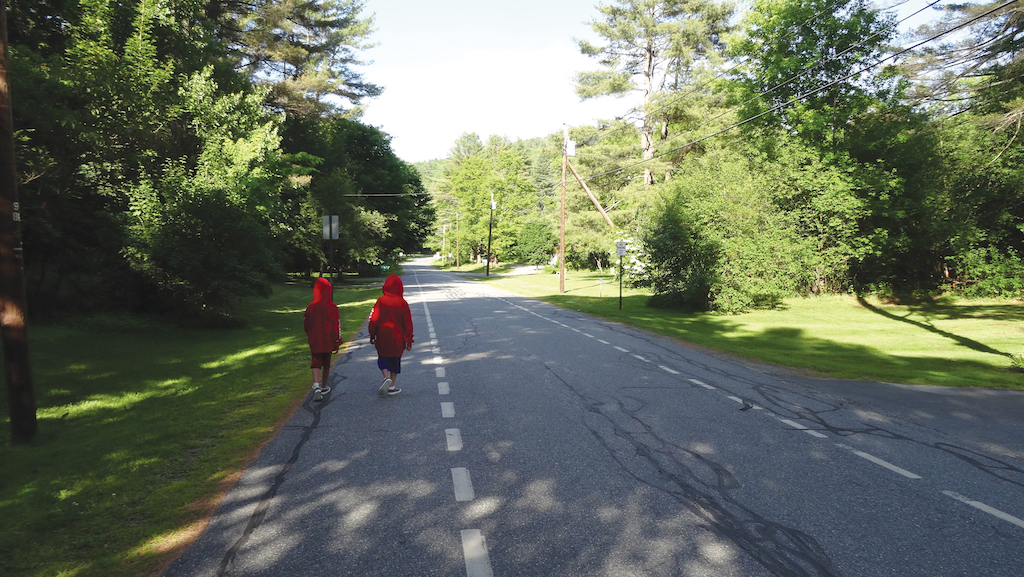
Roads with advisory shoulders accommodate low to moderate volumes of two-way motor vehicle traffic and provide a prioritized space for bicyclists with little or no widening of the paved roadway surface.
Geometric Design
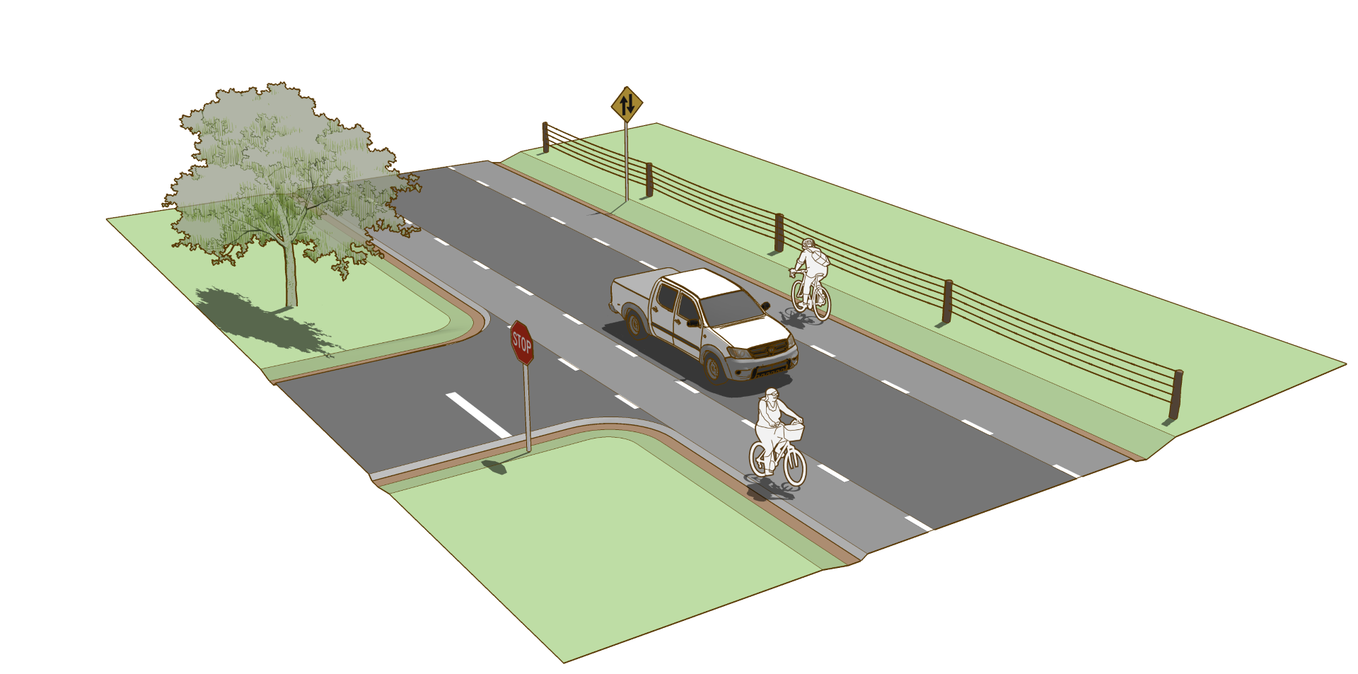
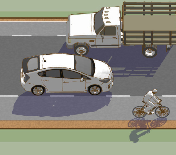
Unlike a conventional shoulder, an advisory shoulder is a part of the traveled way, and it is expected that vehicles will regularly encounter meeting or passing situations where driving in the advisory shoulder is necessary and safe, as illustrated in Figure 2-9.
Advisory ShoulderThe advisory shoulder space is a visually distinct area on the edge of the roadway, offering a prioritized space for people to bicycle and walk.
- The preferred width of the advisory shoulder space is 6 ft (2.0 m). Absolute minimum width is 4 ft (1.2 m) when no curb and gutter is present.
- Consider using contrasting paving materials between the advisory shoulder and center travel lane to differentiate the advisory shoulder from the center two-way travel lane in order to minimize unnecessary encroachment and reduce regular straddling of the advisory shoulder striping.
The two-way center travel lane is created from the remaining paved roadway space after the advisory shoulder has been accounted for.
- Preferred two-way center travel lane width is 13.5–16 ft (4.1–4.9 m) although may function with widths of 10–18 ft (3.0–5.5 m). Table 2-2 describes the impacts of various center lane widths on roadway operations.
An approved Request to Experiment is required to implement Advisory Shoulders, called “dashed bicycle lanes” in the FHWA experimentation process. For more information on the experimentation process, visit http://mutcd.fhwa.dot.gov/.
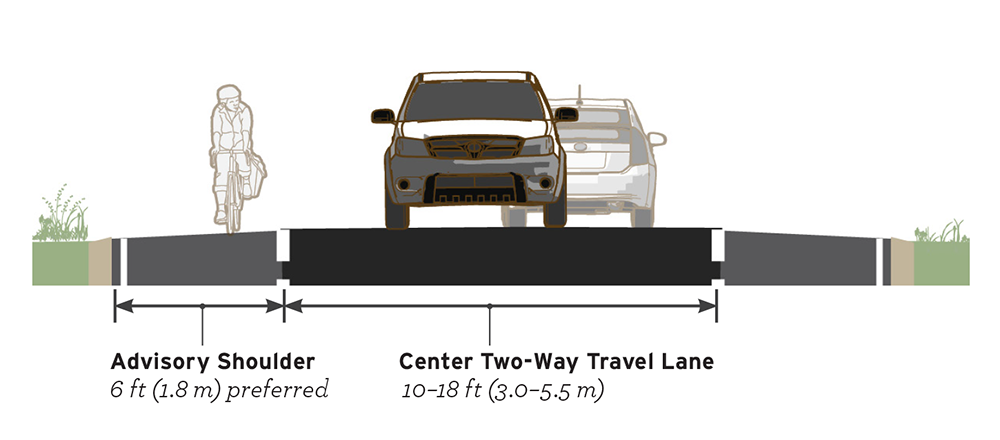
Figure 2-9. Advisory shoulders clarify positioning and yield priority on roads too narrow to provide exclusive travel space. When pedestrians or bicyclists are present, motorists may need to yield to users present in the advisory shoulder before passing.

Figure 2-10. Motorists travel in the center two-way travel lane. When passing a bicyclist, no lane change is necessary.

Figure 2-11. When two motor vehicles meet, motorists may need to encroach into the advisory shoulder space.
Table 2-2. Interactions when vehicles traveling in opposite directions meet by two-way center turn lane width.
Implementing agencies should be advised that the above dimensional guidance is intended to facilitate implementation on common roadway widths in the U.S. As with most treatments, more overall width is preferable to constrained circumstances.
10 ft (3.0 m) Center Travel Lane

13.5 ft (4.5 m) Center Travel Lane
18 ft (15.5 m) Center Travel Lane

Figure 2-12. Total roadway width affects the number of road users that can meet and pass simultaneously. Wider roadways allows for more simultaneous interactions, and can support higher volumes of motor vehicles.
Markings
- A broken lane line used to delineate the advisory shoulder should consist of 3 ft (1.0 m) line segments and 6 ft (2.0 m) gaps.
- Where additional edge definition is desired, stripe a normal solid white edge line in addition to the broken advisory shoulder line.
- In general, do not mark a center line on the roadway. Short sections may be marked with center line pavement markings to separate opposing traffic flows at specific locations, such as around curves, over hills, on approaches to at-grade crossings, and at bridges. At these locations, widen the paved roadway surface to provide space for paved bicycle-accessible shoulders and conventional width travel lanes. See Table 2-3 for sight distance requirements.
Hanover, NH – Pop 11,250
Western Transportation Institute


Figure 2-14. At crossings of minor intersections and driveways, maintain the striping and construction material (if used) of the advisory shoulder.
Table 2-3. Minimum Passing Sight Distances for No-Passing Zone Markings. Adapted from MUTCD Table 3B-1.
Signs
Use signs to warn road users of the special characteristics of the street. Potential signs for use with advisory shoulders include:
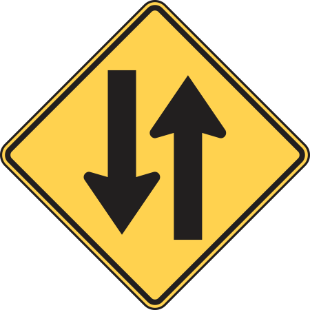
- As illustrated in Figure 2-13. Use an unmodified Two-Way Traffic warning sign (W6-3) to clarify two-way operation of the road.
- Use a NO CENTER LINE warning sign (W8-12) to help clarify the unique striping pattern.
- Use a NO PARKING ON PAVEMENT (R8-1) to discourage parking within the advisory shoulder.
Figure 2-13. The W6-3 two-way traffic warning sign can clarify undivided two-way operation of the advisory shoulder configuration.
Intersections
Advisory shoulder designs work best on road segments without frequent stop or signal controlled intersections that require vehicles to stop within the roadway. The designer should strive to maintain the visual definition of the advisory shoulder through all driveways and street crossings, and provide a conventional shoulder at controlled intersections.
- At minor street crossings, use a dotted line extension on both sides of the advisory shoulder to maintain delineation of the advisory shoulder space Figure 2-14.
- If contrasting pavement material is used, maintain the material through driveway crossings and minor intersections.
- Where the road is controlled by a stop sign or traffic signal, discontinue the advisory shoulder 50 ft (15 m) in advance of the intersection. At these locations, provide a bicycle accessible paved shoulder outside of the travel lanes or design for operation as a shared roadway.
Bloomington, IN – Population 82,000
City of Bloomington Planning and Transportation Department
Implementation
In order to install advisory shoulders, an approved Request to Experiment is required as detailed in the MUTCD 2009, Sec. 1A.10. FHWA is also accepting requests for experimentation with a similar treatment called "dashed bicycle lanes."
Accessibility
Advisory shoulders as described here are not intended for use by pedestrians. When advisory shoulders are intended for use by pedestrians, they must meet accessibility guidelines.
Edina, MN – Population 49,300
Alta Planning + Design

Advisory Shoulder Case Study
Hanover, New Hampshire
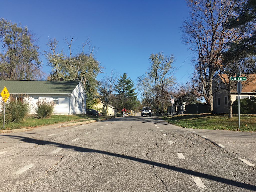
In 2012, Hanover completed a bicycle and pedestrian planning effort. This plan identified Valley Road as a local bicycle connection in the overall network. In 2013, Hanover completed a Safe Routes to School (SRTS) Plan, which introduced the idea of using advisory shoulders (called advisory bike lanes for this project) on Valley Road. Hanover’s Bicycle and Pedestrian Committee (HBPC) advocated to use Valley Road as a pilot project for advisory shoulders. The HBPC surveyed the Valley Road neighbors and built support for a pilot project. While there was some resistance, the neighborhood was generally supportive of the idea. Hanover’s Department of Public Works was open to the idea and it was presented to the town select board who approved installation of advisory shoulders on Valley Rd. The advisory shoulders were painted on about 400 meters of Valley road in the summer of 2014.
In 2016 an evaluation report was produced with traffic counts and results from a follow up survey. Based on the success of the Valley Road advisory shoulders, Hanover is currently evaluating adding advisory shoulders to another important bicycle and pedestrian connection between schools and neighborhoods. Factors in the success of the advisory shoulders were the leadership of the HBPC, support from the adjacent neighbors, the willingness to pilot them by the Department of Public Works and inclusion of Valley Road and advisory shoulders in both the SRTS and Bicycle and Pedestrian Plans.
Community Context
Hanover, NH, is a town of approximately 11,000 with 8,000 living in the town center. Hanover is home to Dartmouth College with a student population of 6,300. Hanover is located on the Connecticut River and has a dense builtup area surrounded by small suburban neighborhoods that transition quickly to
a very rural setting.
Key Design Elements
The advisory shoulders project was built on a low-volume, low-speed, residential road. Implementation included pavement markings and signs.
Roles in the Network
Valley Road is a local bicycle connection between neighborhoods with schools, the downtown, and the Dartmouth College campus. Sidewalks were
removed due to root damage and were not replaced because the neighborhood preferred the rural look of streets without sidewalks. Advisory shoulders use existing pavement to provide space prioritized for bicycles and pedestrians at very low cost.
Funding
The Hanover Bicycle and Pedestrian Plan and the advisory shoulders project were both accomplished with funding from the HBPC, which is funded by a $5 local fee on vehicle registration that was passed by the select board to support alternative transportation and generates approximately $30,000 annually.
For more information, refer to the City of Hanover Public Works Department.
Selected Examples
Works Cited
Cardiff Council. Cardiff Cycle Design Guide. 2011.
Federal Highway Administration. Bicycle Facilities and the Manual on Uniform Traffic Control Devices. 2015. Retrieved from: https://www.fhwa.dot.gov/environment/
bicycle_pedestrian/guidance/mutcd/dashed_bike_lanes.cfm
Federal Highway Administration. Manual on Uniform Traffic Control Devices. 2009.
Transport for London (TfL). Centreline Removal Trial. 2014.
Wiltshire County Council. White Line Carriageway Markings. April 2014.